 Miles Sisk
Life as a housing developer is a never-ending word problem. The inputs and outputs in a proforma change daily, and years can be spent in design review, court battles and public hearings before ground is broken. All of that drives up the cost of new development, and the cost is passed on to the people who will eventually rent or buy.
What if neighborhoods front-loaded the design review process for developers? In the last post we looked at Dynamic Density, a model for letting a neighborhood allocate its share of new housing and update its own zoning. It forces cities to plan for growth, and it gives neighbors the power to shape it. Once that density is allocated, the neighborhood can go one step further and choose a catalog of building types it has already approved; the village then commissions stamped plan sets for each, so a developer who builds to the catalog gets a fast track through permitting. Design, review and approval happen once, in public, before anyone buys a lot. By the time a developer shows up, the where, the what and the number are already decided. The developer's job becomes accepting a decided project. Call it the pickup.
None of the parts are new, and I want to be exact about that, because the whole point is that none of them have to be. Neighborhood allocation is Dynamic Density. Even the neighborhood's cut of the yield has a draft: when we started ReUrbanist Collaborative we proposed setting each neighborhood up as a community development corporation inside a Prosper Portland district, so it keeps part of the system development charges and new tax revenue from the growth it accepts. That is the answer to the question every neighbor asks first, which is what we get for saying yes. Pre-approved plan catalogs exist: South Bend, Indiana launched one in 2021 and now offers seven plan sets from an accessory unit to a six-plex, with 18 homes built by last spring. Public-plans-and-services-first exists: Copenhagen's development corporation lays the streets and the Metro, then sells serviced plots. And public land on long ground leases exists. Jonathan's 2019 proposal for Portland's golf courses put every new building on a 99-year ground lease on land the city kept, and New York has run that model for fifty years at Battery Park City, where a state corporation owns 92 acres on ground leases, has sent $461 million to affordable housing since 2010, and committed $500 million more in 2024. A ground lease is a lease. The public body that leases keeps the appreciation its own pipes created, which is the Part one argument with a deed attached.
New development pays in; the neighborhood decides where it goes.
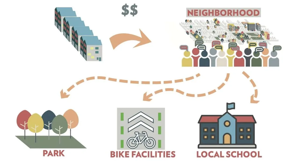
What has not been done is welding those parts together with one more piece, the per-acre number from the first post, as the approval criterion. The board approves a site because the types the neighborhood chose will clear a stated tax yield per acre and the maintenance tail is priced, and it recovers what it spends on streets and pipes through land it keeps rather than through one developer's increment. That weld is the whole claim of this series.
Left: the public plans, plats and pipes, keeps the land, and recovers its spend through ground rent and per-acre yield. Right: the model Chicago runs today.
The four parts, their precedents, and the six-step pickupShow the math
| Part | Precedent | What it proves |
|---|---|---|
| Neighborhood allocation by type | Dynamic Density, Irvington, Feb 2024 (Potestio and Konkol) | Neighbors will place a fixed number if the number is fixed first. |
| Neighborhood shares the yield | ReUrbanist Collaborative proposal, Portland: a neighborhood community development corporation inside a Prosper Portland district, capturing part of system development charges and new tax revenue | The incentive for a neighborhood to say yes. Proposal only; not adopted. |
| Public plans and services first, lots sold serviced | By & Havn, Copenhagen (55% city, 45% state, formed Oct 2007) | Infrastructure before buildings, financed by the plots it serves. |
| Public keeps the land | Battery Park City Authority, New York (92 acres, ground leases since the 1970s; $461M to affordable housing since 2010; $500M more, July 2024) | Ground rent recovers the public's infrastructure spend and the uplift. |
| Pre-approved plan catalog | Build South Bend, Indiana (2021; seven stamped plan sets; 18 homes by May 2025) | Stamped plans cut soft costs for small builders. |
| Per-acre approval floor | Part one's method (Urban3, Smart Growth America, Halifax) | The criterion that makes the first four fiscal, not aesthetic. |
The pickup for one site, in order.
- The council names the site's share of new homes.
- The neighborhood allocates them on the survey map, choosing from a short menu of building types measured from the town's own streets.
- The village plats the site on standard lots, prices the streets and pipes, and adopts a per-acre tax-yield floor by resolution.
- A TIF district or a Special Service Area funds the streets and pipes.
- The village or the land bank holds title.
- Lots go out on ground leases with stamped plans, two at a time, to the first builder who commits to an approved type; early adopters and local builders get the incentive.
Sources: ReUrbanist Collaborative, How it Works; By & Havn annual reports; Battery Park City Authority press releases (2024); City of South Bend, Build South Bend; Illinois Compiled Statutes cited below.
If that sounds like a lot to ask of a village, look at what Chicago already asks of itself. The 62 acres at Roosevelt and Clark were approved in 2018 for a $7 billion plan. In 2019 the city promised $551 million in future tax increment to reimburse the developer for a Red Line station, Metra tracks, streets and a seawall. Nothing got built for six years. The site moved in 2025 only when a private owner agreed to fund a soccer stadium outright, and this July the city rewrote the 2019 deal and signed a second one for a garage: up to $425 million in tax increment between them, now aimed at streets, track work, a river wall and a 1,200-space garage the city will own. Public infrastructure first, private construction second, on a plan already decided. That is the pickup in everything but the land. The difference is that the developer keeps the 62 acres and the increment, and the public gets a parking garage. Foundry Park, on the Lincoln Yards site, is the same movie: $201.6 million of public money for streets, parks and a bridge, seven years after the first developer promised to build them.
Public support authorized or amended, by site and year. Millions of dollars.
The 78 and Foundry Park: public commitments by dateShow the math
| When | Site | Commitment |
|---|---|---|
| 2018 | The 78 | Planned development approved: $7 billion, up to 10,000 units, Related Midwest. |
| 2019 | The 78 | Roosevelt/Clark TIF redevelopment agreement: up to $551 million in reimbursements for a Red Line station at 15th Street, Metra track relocation, streets and seawall. |
| 2022 | The 78 | Redevelopment agreement amended; TIF reimbursement restated at up to $453.7 million. |
| 2025 | The 78 | Chicago Fire owner Joe Mansueto commits private funding for the $750 million stadium; construction begins. |
| July 2026 | The 78 | City Council approves an amended and restated redevelopment agreement for the public ways (SO2026-0026267) and a separate agreement for the garage (SO2026-0026275): up to $424.9 million in TIF between them, reimbursing the developer for LaSalle, 13th, 14th and 15th street work, Metra track upgrades, South Branch river wall, open space, and a 1,200-space garage the city will own and operate (public except for 45 Fire event days a year). This replaces the earlier reimbursement figure; it is not additional. |
| Sep 23, 2026 | Foundry Park | City Council approves $201.6 million in TIF for streets, parks, riverwalk and the 606 bridge. |
Sources: City of Chicago DPD release, July 2026; The Stadium Business, July 16, 2026; NPR/WBEZ, April 11, 2019 on the original $551 million; Chicago City Council records via Councilmatic: O2019-2574 (2019 agreement, passed April 10, 2019, 31 to 14), SO2026-0026267 and SO2026-0026275 (July 2026); WTTW and Urbanize Chicago on Foundry Park, Sep 2026.
None of this needs new state law. An Illinois village already zones and plats its own land. Tax increment financing, the tool that funded Lincoln Yards, The 78 and Foundry Park, runs 23 years and pays for exactly the things the pickup needs: land, streets, pipes, site preparation. A Special Service Area lets a neighborhood tax itself for its own improvements or bond against them, which is the Illinois version of the neighborhood development corporation we proposed at ReUrbanist Collaborative; Oak Park already has one on its tax bill. The Cook County Land Bank can hold title. The per-acre floor is a board resolution. A village board could adopt the whole thing on a Tuesday night. In Illinois every village downtown is zoned by its own trustees, and they are the audience I am writing for.
Who has the authority, with statutesShow the math
| Step | Who | Authority |
|---|---|---|
| Name the share; adopt the per-acre floor | Village board or city council | Home rule and municipal zoning power, 65 ILCS 5/11-13; a resolution. |
| Zone and plat | Municipality (counties zone unincorporated land only) | 65 ILCS 5/11-13; county zoning at 55 ILCS 5/5-12001. |
| Fund streets and pipes | Municipality through a TIF district | Tax Increment Allocation Redevelopment Act, 65 ILCS 5/11-74.4; 23-year life, extendable by the General Assembly; eligible costs include land, site preparation and public works. |
| Neighborhood self-tax or bond | Special Service Area | 35 ILCS 200/27; defeated if 51 percent of owners and electors object. |
| Hold title | Village, or the Cook County Land Bank Authority | Land bank formed by county ordinance, 2013. |
| Ground leases; stamped plans | Municipality as lessor; plans commissioned by the village | Ordinary municipal contracting. |
Sources: Illinois Municipal Code, 65 ILCS 5/11-13 (zoning) and 65 ILCS 5/11-74.4 (tax increment allocation; 23-year completion rule at 11-74.4-3.5); Counties Code, 55 ILCS 5/5-12001 (county zoning outside municipal limits); Property Tax Code, 35 ILCS 200/27-55 (special service areas: blocked only if 51 percent of resident electors and 51 percent of owners object); Cook County Land Bank Authority (formed by county ordinance, 2013). Statute text checked against ilga.gov on Oct 21, 2026.
Three seams, named, because a trustee will find them anyway and I would rather be the one pointing. First, the arithmetic: almost no town computes tax yield per acre, and the model needs that number before it spends a dollar. Second, timing: a TIF or a bond against future lease income is a real risk if lots are slow to go. Third, financing: a serviced lot with a stamped plan strips the soft costs off a small builder's proforma, but it does not lend to them. The honest version is that the public takes the timing risk in exchange for keeping the land, and that it already takes that risk today, later and worse, without keeping anything.
Years, on one scale.
So here is the pilot. One village or small city names one site it already owns or can hold through the land bank: stalled under at least one prior master plan, next to pre-1940 fabric the Historic Resources Survey has already mapped, somewhere between five and forty acres. The council names the site's share. The neighborhood association runs the allocation on the survey map with five building types measured from the town's own streets. The village plats it on standard lots, prices the pipes, and adopts a per-acre floor by resolution. A TIF or a Special Service Area funds the streets. The village or the land bank holds title. Lots go out on ground leases with stamped plans, two at a time, to whoever builds the approved type first, with the incentive aimed at early adopters and local builders. The number the board approves is dollars per acre, not units. Waukegan's lakefront is where I would start: a Skidmore, Owings & Merrill master plan adopted in 2003 and still described as "underway" on the city's website, city-owned parcels on the water, and a developer panel convened by the RTA and the Urban Land Institute in 2025 that told the city to line up its vision, approvals and funding before anything else moves.
I will run the workshop and the per-acre arithmetic for the first village that wants to try it.
Four slides, four posts, one afternoon with friends that turned into a plan a village could adopt by resolution. That is what the party was for.